Groundwater Area includes Columbia Heights and Hilltop

Anoka County residents and businesses get their water from wells that draw from groundwater aquifers located directly below us.  As Anoka County grows, so does our need for water. Is there enough groundwater?

On January 2, 2014 the Minnesota Department of Natural Resources (DNR) had established the North & East Metro Pilot Groundwater Management Area “working boundary” that included Blaine, Centerville, Circle Pines, Columbus, Fridley, Lexington, Lino Lakes and Spring Lake Park in Anoka County.

On March 7th, the DNR added three communities (Columbia Heights, Hilltop and Minneapolis – east of the Mississippi River) into the North & East Metro Groundwater Management Area. The additional communities are located within, and connected to, the natural groundwater unit that is bordered by the Mississippi River on the west and south. 
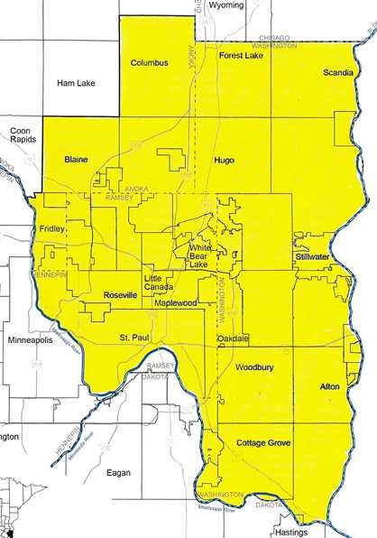
North & East Metro Groundwater Management Area (Mar. 5, 2014)

Currently the DNR is working with communities and businesses within the North & East Metro Groundwater Management Area to prepare and implement a groundwater sustainability plan that will:

  • Improve information about area groundwater resources;
  • Reinforce partnerships for sustainable groundwater use;
  • Improve compliance with existing groundwater regulations; and
  • Assure a sustainable groundwater supply for future generations.

To illustrate the importance of our groundwater resources the Minnesota Department of Natural Resources has released a video Living on the Edge: Our Water Supply at Risk

WHAT CAN YOU DO? Consider home and business water conservation options that are provided on the WaterSense website (USEPA) or on the Water Conservation Toolbox webpage (Metropolitan Council).  Combined, our conservation efforts will add up.

The Safe Drinking Water Act is turning 40 years old

On December 16, 1974, President Gerald Ford signed into law the Safe Drinking Water Act (SDWA) intended to ensure safe drinking water for the public.  The SDWA applies to all public water supply systems including municipal water utilities and wells that serve mobile home parks, schools, churches and office buildings.  A home or cabin well system is not a public water system.  See Minnesota’s Safe Drinking Water Act 40th Anniversary video (YouTube; 6:43).

Since 1972, the Anoka County Community Health and Environmental Services Department has provided water testing and advice to owners of private wells. Private well owners are encouraged to test the safety of their water annually by picking up a test kit at their city hall or the Anoka County Environmental Services office (Suite 360, 2100 Third Avenue, Anoka, MN 55303). For more information call the Environmental Services office at 763-422-7063.

Water Spot on: DRINKING WATER OPERATOR CERTIFICATION

A mandatory certification program for water supply system operators was established by Minnesota Statutes in 1971, and is administered by the Minnesota Department of Health, Drinking Water Protection Section. In order to be certified the operator must demonstrate that he or she possesses the skill, knowledge, experience, and education necessary to operate a system successfully.

There are currently over 250 public water supply systems in Anoka County. The certified water operators who maintain the wells, pumps, pressure tanks and water towers are protecting public health by providing safe, reliable drinking water. To see how public water system operators protect your drinking water – view the EPA video Water You Waiting For? (opens in a pop-up window).

Water protection and management in your community

Anoka County communities have established water resource management programs with their watershed management organization or a watershed district. The City’s surface water management programs deal with broad land runoff (“nonpoint” source) and specific wastewater (“point” source) pollution. Point source pollution includes the discharge of treated wastewater effluent through a pipe. Nonpoint sources of pollution result from many of the everyday activities and actions of people. These include applying fertilizer to lawns in an amount that exceeds what the grass can use, plowing an agricultural field such that erosion results, blowing grass clippings into the street, or driving a car that exhausts improperly burned hydrocarbons or leaks oil. All these add up to major nonpoint source pollution loading of our receiving waters.

Wellhead Protection programs are a City’s means to address groundwater pollution near water wells that can contaminate the source of the community’s drinking water supply.  Our water resources are an important part of our lives and your city is taking measures to ensure that we have clean and plentiful water now and in the future.

Municipalities-Map(509)

For information about how your community is addressing the management and protection of local water resources see their website, plans, or contact the city clerk for more information:

Looking for water information?

The Anoka Conservation District and the seven (7) watershed management organizations are a terrific source of water information and protection activities in Anoka County.

The Anoka Conservation District (ACD) is a non-regulatory county level subdivision of state government. ACD provides technical and financial assistance to private landowners to manage natural resources in a way that conserves and improves soil and water resources. When established in 1946, ACD largely worked with agricultural producers but has since evolved to serve the changing demographics of the county.

Anoka Conservation District (763-434-2030)

Watershed management organizations manage water resources and surface water drainage systems to prevent property damage, maintain hydrologic balance, and protect water quality for the safety and enjoyment of citizens and the preservation and enhancement of wildlife habitat. Do you know what watershed you’re in?

Watersheds(548x576)

Coon Creek Watershed District (763-755-0975)

Rice Creek Watershed District (763-398-3070)

Note: TMDL studies are expected for Anoka Chain of Lakes and Peltier.

Lower Rum River Watershed Management Organization

Upper Rum River Watershed Management Organization

Sunrise River Watershed Management Organization

Mississippi Watershed Management Organization (612-465-8780)

Vadnais Lake Area Watershed Management Organization (651-204-6070)

Anoka County Highway Department wins 2014 Environmental Leadership Award

The Anoka County Highway Department was awarded Freshwater Society’s 2014 Environmental Leadership Award at the 2014 Road Salt Symposium for reducing the use of salt on roadways without compromising public safety.

Anoka County is doing their part to reduce pollution of road ditches and waterways.  Residents, businesses and property owners are encouraged to keep pollution out of ditches, streams, lakes and rivers by wisely using salt on sidewalks, driveways, and parking lots. See the fact sheets for tips to reduce pollution on Anoka County Highway Department’s Know The Flow webpage. For more information about the Highway Department’s plowing schedule and snow removal practices call Sherree Hitzemann at 763-862-4210.

Pre-order your Rain Barrel & Compost Bin

Order online to have a rain barrel and compost bin waiting for you to pick up

Spring is right around the corner, which is a great time to start composting in your backyard and collecting rainwater for reuse! A rain barrels allows you to capture rainwater from your roof or downspout that you can reuse in your lawn or garden, reducing runoff and conserving water (EPA YouTube Video). Composting is an easy way to recycle your food and yard waste into a nutrient-rich fertilizer.

The Recycling Association of Minnesota has scheduled an Anoka County event at the Coon Rapids Recycling Center (June 14, 2014). Pre-ordered compost bins ($55) and rain barrels ($69) will be waiting for Anoka County residents to pick up.  Kitchen pails for collecting food scraps will also be available.

For more information go to the RAM Coon Rapids Recycling sale website.

Lino Lakes addresses the safety of their drinking water

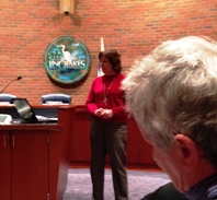
The City of Lino Lakes held a public information meeting (Jan. 27, 2014) to present part 1 of their updated wellhead protection plan to residents and businesses within the city and inside the City’s designated Drinking Water Supply Management Area (DWSMA).  The Lino Lakes DWSMA establishes a land area, around the City’s municipal wells, that have a greater potential to influence the quality of groundwater captured by the wells. 

Lino Lakes is moving forward to prepare part 2, of their Wellhead Protection Plan that will include:

  • identifying pollution sources within the DWSMA;
  • determine the problems and opportunities in protecting the source of drinking water;
  • establish goals; and
  • establish a plan of action to reach protection goals.

Use the DWSMA map app. to find out if your property is inside a DWSMA. For more information contact the Marty Asleson (Environmental Coordinator, City of Lino Lakes) at 651-982-2435.

(Photographed: Nancy Zeigler, WSB & Associates)

Anoka County supports groundwater sustainability and economic vitality

Anoka County supports efforts for groundwater sustainability and economic vitality. The Anoka County Board of Commissioners has passed a legislative platform resolution in support of principles that protect our water resources while maintaining our growing economic vitality. Points in Anoka County’s position include:

  • Anoka County’s future economic vitality is dependent on maintaining an environment that supports vigorous communities;
  • A community that is vital and sustainable is of greater value to individuals and businesses;
  • Pristine natural features such as clean lakes and land enhance the value of a community.

Management and protection of Anoka County’s natural resources are necessary to maintain healthy and vital communities. An important local landscape feature is the “Anoka Sand Plain” (named after the county for which it is most prominent) that acts as a primary groundwater recharge zone to aquifers used for water supply throughout the metropolitan area.

Recently, the Commissioner of the Minnesota Department of Natural Resources (DNR) designated a north and east zone of the metropolitan area (including part of Anoka County) as a Groundwater Management Area, or GWMA. The GWMA designation is in response to lowering water levels in White Bear Lake that has been attributed to excessive pumping from large capacity (including municipal) wells. In recent years, concern has also been expressed over the lower levels of Bunker, Crooked and Itasca lakes in Anoka County. The DNR will address managing water use within the GWMA through focused evaluation, conservation education and sustainable groundwater use.

The Anoka County Board of Commissioners joins with others in support of: Taking action toward results which will lead to groundwater sustainability, while balancing groundwater management with the community economic development vitality efforts. In addition, Anoka County will continue to be an engaged stakeholder in the DNR’s efforts regarding White Bear Lake and the new Groundwater Management Area.

The Know The Flow website is an example of Anoka County’s approach to managing water resources through coordination between county, city and watershed management agencies. The Anoka County Water Resources Management Report (October, 2009) provides agencies with a framework for cooperation in protection and management of water resources.

For more information contact Anoka County Environmental Services at 763-422-7063.

Drinking water protection map now includes the Mississippi River

UPDATE (1/13/2014) A chemical spill that polluted a Charleston, West Virginia river last week is an example of the importance in managing potential pollutants that can contaminate a drinking water supply. Minneapolis and St. Paul regional water systems get their water from the Mississippi River. For information on preventing pollution of the Mississippi River and protecting Twin Cities drinking water supply go to the Upper Mississippi River Source Water Protection Project webpage. If you own or operate a chemical storage tank go to the Minnesota Pollution Control Agency’s Tank Compliance and Assistance Program website for information on preventing pollution and spills that may contaminate drinking water sources.

The Anoka County Wellhead Protection interactive map application has been expanded to display the Drinking Water Supply Management Areas (DWSMA) of the Mississippi River. The Mississippi River is the source of drinking water for many communities throughout the Twin Cities, including Columbia Heights and Hilltop in Anoka County. To see the Mississippi River DWSMAs click on the “more…” button (upper right side of map) and check the “Mississippi DWSMAs” box.

Keeping drinking water safe includes preventing pollutants from reaching the water source. The cost of prevention is much less than the price of treating polluted drinking water or finding an alternative source of clean water.

In Anoka County the source of drinking water is typically a water well (groundwater). Public water suppliers are implementing their wellhead protection programs to prevent groundwater pollution from reaching their wells. By preventing pollution of the land and groundwater – near a community well – you and your public water supplier are keeping your drinking water safe and helping to establish a sustainable source for the future. For more information about wellhead protection in your community contact your city water utility or click on the DWSMA in the Wellhead Protection Interactive Map for contact information about the wellhead protection manager.

Keeping pollution out the Mississippi protects the health of over 900,000 people including the residents of Columbia Heights and Hilltop in Anoka County. Preventing pollution of land, ditches, creeks, streams that add water to the Mississippi requires the cooperation land owners, residents and businesses that are near the river or a storm sewer, creek or steam that empties into the river.

State Fish Art Contest

The STATE-FISH ART Contest is open worldwide to all children in grades K -12 in any public, private or home-school, any youth group, after-school program, youth camp, scout troop, art class, etc., or just an individual kid that wants to enter! 

Essentially any child of K-12 age is eligible as long as a responsible adult reads, agrees to and signs their entry form.  Only one entry per child will be accepted.

Every year, there are one or two very disappointed students because they, their teachers or their parents did not follow our simple requirements (rules). The unfortunate result is disqualification by the judges…very, very sad indeed.”  ~ Karen R. Hollingsworth, Manager, STATE-FISH ART

Deadline to submit your entry is March 31st.

Wildlife Forever’s  STATE-FISH ART Contest is an exciting, multimedia conservation education program designed to increase awareness of and respect for aquatic resources creating stewardship.

Powered by WordPress